Branching Out – Watershed Mention in Deeds Can Help Place Property
These themes are sometimes difficult to formulate a specific
story about someone in the family. I often search for the word in my genealogy software
and see what comes up. It is hit and miss whether that works. Today, I searched
for “branch.” I found two people who have deed descriptions that mention “branch.”
Land Description
Knowing the name of a branch of a creek or river, can be helpful in place a
piece of property that is only described as “north ten degrees west forty-three
rods to an oak” etc. Having the name of a branch, creek, river, or other
watershed type can help place that property, if not exactly, at least close to
where it was located. To place it more precisely, locating the deed
descriptions of all of his neighbors could be all that is needed.
For example, Arthur Core of North Carolina received a patent
from the Royal Governor, William Tryon on 4 May 1769 for 54 acres.[1]
The description in the land patent book stated:
“54 acres Dobbs the north side of Nuce [Neuce] river on both
sides of the Hollands Branch making out from Beaver dam Swamp beginning at a
pine said Cores Corner tree the west side of Hollands Branch about 60 poles
from the Branch and running north 15 west 119 poles to a pine a corner of his
other survey then north 40 east a long his line 178 poles to a pine another of
his corners then along his line to the beginning.”
There may not be enough to plat this piece of property on a
topo map, but there are some watershed descriptors that may help, especially if
a contemporary map is found of the location. We have the Neuce River, the
Hollands Branch, and Beaverdam Swamp.
A search of these terms together brought up the North
Carolina DENR, Division of Water Quality, an alphabetic list of North Carolina
watersheds. In the Neuse River Basin, Beaverdam Swamp had five listings:[2]
- Beaverdam Swamp, subbasin NEU04, stream index no. 27-52-6-4, map no. F25NW8, class C;NSW
- Beaverdam Swamp, subbasin NEU07, stream index no. 27-86-11-3, map no. D26SE5, class WS-III;NSW
- Beaverdam Swamp, subbasin NEU09, stream index no. 27-97-8-3-1, map no. F30SE8, class C;Sw,NSW
- Beaverdam Swamp, subbasin NEU11, stream index no. 27-101-3, map no. G28SW6, class C;Sw,NSW
- Holland Branch, subbasin NEU12, stream index no. 27-55-1-1, map no. F26NE4, class WS-IV;NSW
There was also a mention of Core Creek and Core Sound. Could
that be part of Core’s land?
- Core Creek, subbasin NEU08, stream index 27-90, map no. G29NW6, class C;Sw,NSW
- Core Sound, subbasin NEU14, stream index 27-149, map no. H33NE8, class SA;ORW, NSW
- Core Sound, subbasin WOK05, stream index 27-149, map no. H33NE8, class SA;ORW,NSW
At this time, I’m not sure how to locate these maps using
the above designations. The stream index numbers and the map numbers don’t see
to coincide with each of the watershed pieces. More research is needed.
Locating a Map
Trying to find these places on a map online is difficult. I found a site that
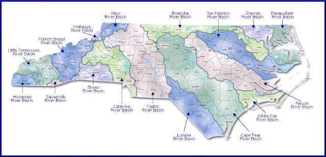
has a map of the North Carolina Watersheds.[3]
This map at least shows where in North Carolina, the Neuse River Basin is
located. It flows east to the Atlantic.
Dobbs County is no more. It was formed in 1758 from Johnston County. In 1779, the western part of Dobbs became Wayne County and I have records of the Core (Coor) family living in Wayne County. The rest of Dobbs was divided into Glasgow County and Lenoir County in 1791 and no longer exists.[4]
Here is a map of Wayne County, published in 1881.[5] It shows Beaverdam meeting up with Neuse River. It is possible that the western branch was called Holland. More research is needed.

Another map was found of the Neuse River basin.[6]
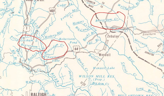
This shows how hard it can be with creeks with the same name in different locations. There is one flowing into Little Creek (upper right) and two flowing into Neuse River. Still no Holland Branch in any of these maps.
Even if I don’t locate the exact location of Arthur’s land using these maps, I will at least have an idea of the general area. With the metes and bounds land description describing trees and posts, that is pretty good.
#52Ancestors-Week 5: Branching Out
This is my fifth year working on this year-long prompt,
hosted by Amy Johnson Crow (https://www.amyjohnsoncrow.com/)
at Generations Cafe. I write each week in one of my two blogs, either Mam-ma’s Southern Family or
at My Trails
into the Past. I have enjoyed writing about my children’s ancestors
in new and exciting ways.
Copyright © 2022 by Lisa S. Gorrell, Mam-ma's Southern
Family, All rights reserved.
[1] North
Carolina Patent Book, book 20, p 418, Dobbs County, file no. 634, Arthur Core,
digital image, NC Land Grants (https://nclandgrants.com/grant/?mars=12.14.56.635&qid=743484&rn=1
: accessed 2 Feb 2022); citing State Archives of North Carolina MARS database.
[2] “Neuse
River Basin,” NC DENR, Division of Water Quality, https://www.carolana.com/NC/Transportation/Neuse_River_Basin.pdf.
[3]
North Carolina Watersheds, https://www.carolana.com/NC/Transportation/nc_watersheds.html.
[4] “Dobbs
County, North Carolina,” Wikipedia (https://en.wikipedia.org/wiki/Dobbs_County,_North_Carolina
: viewed 1 Feb 2022).
[5] Tucke,
“Wayne County,” map, 1881, digital image, North Carolina Maps (https://dc.lib.unc.edu/cdm/singleitem/collection/ncmaps/id/254/rec/7
: viewed 2 Feb 2022).
[6] North
Carolina Dept. of Water and Air Resources, “Neuse river Basin-1 (Headwaters to Kinston
Area), 1968, North Carolina Maps (https://dc.lib.unc.edu/cdm/singleitem/collection/ncmaps/id/4585/rec/30
: viewed 1 Feb 2022).


Very interesting methodology when the wording is tricky in some cases!
ReplyDeleteIt's hard to imagine using the metes and bounds method now. Did our ancestors really believe the "big oak" would still make a good measuring point years into the future? Thanks for sharing!
ReplyDeleteMaybe Holland is the last name of a neighbor that lived nearby.
ReplyDelete