 |
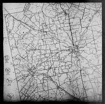
1940 Census Enumeration District Maps - Texas - Erath County - ED 72-1 - ED 72-20
National Archives |
I was looking at photos about baseball on the National Archives site when I thought to search for photos about Erath County, Texas, where my grandmother is from. Up popped maps depicting the 1940 Enumeration Districts. Wow, that will be helpful when the 1940 U.S. Federal Census comes out in 2012. There will be no index immediately, so having a map to narrow down which ED to search page by page will cut my searching time down to a manageable level.
I believe my grandparents (Tom J & Pansy Johnston) and mother (Lela Nell Johnston) were living in Stephenville, Erath County, Texas in 1940. The war hadn't started yet, so my grandfather was not yet in the U.S. Navy. He would be working in some carpentry trade.
 |
| ED 72-1 to 72-4 |
There was also a description of these EDs:
My grandmother's parents, George Warren & Lela Ann Lancaster, were located in Ward 1 in the 1930 census at 1020 W Green Street. That will be where I'll start first. Perhaps Tom & Pansy will be living nearby.
Copyright © 2011 by Lisa Suzanne Gorrell, Mam-ma's Southern Family


.jpg)
Hi Lisa. Can you tell me what the 72-1, 72-2 etc means? Is that a dwelling number? I have an ancestor Im trying to find where he lived from an 1880 census. I found an Erath map from 1879 but hedidnt own the land. Trying to figure out how to find him by the census record.
ReplyDeleteED stands for Enumeration District. That was how the census bureau divided up an area for the census taker. Stephenville, Texas was divided into four districts because of its size. The whole county had twenty districts. The dwelling numbers are on the side of the sheet next to the family number. Neither of these are their address. To find him on the map, check out neighbors who owned land and look for them on the map. You probably won't get his exact location but will know the general area.
Delete